

A watershed is the land area that drains to a common outlet like a lake, stream, river or bay. The Wood-Pawcatuck Watershed is located in southwestern Rhode Island and southeastern Connecticut, between the major metropolitan areas of New York and Boston. The watershed, which drains to the common outlet of the Pawcatuck River and Little Narragansett Bay, covers a land area of more than 300 square miles (194,000 acres). The rivers, lakes, ponds, wetlands, and streams of the watershed serve as an important wildlife habitat, recreational resources, and water supplies for agricultural production. Significant groundwater resources underlie the watershed and remain the sole source of drinking water for people living within the watershed.
The Rivers
The Wood-Pawcatuck Wild and Scenic Rivers designation includes the seven major rivers of the Wood-Pawcatuck Watershed, as well as twenty-four named tributaries, and any other perennial stream within the watershed. Click on the links below to learn more about each river.
Click on the river on the map or on the list of names to see more about each river, including maps and photographs of each river.
Click on the town names to see maps of the towns with the rivers and streams in each town.
The Rivers:
Beaver River
Chipuxet River
Green Fall – Ashaway River
Queen – Usquepaugh River
Pawcatuck River
Shunock River
Wood River
The Towns:
Charlestown, RI
Exeter, RI
Hopkinton, RI
North Kingstown, RI
North Stonington, CT
Richmond, RI
South Kingstown, RI
Sterling, CT
Stonington, CT
Voluntown, CT
Westerly, RI
West Greenwich, RI
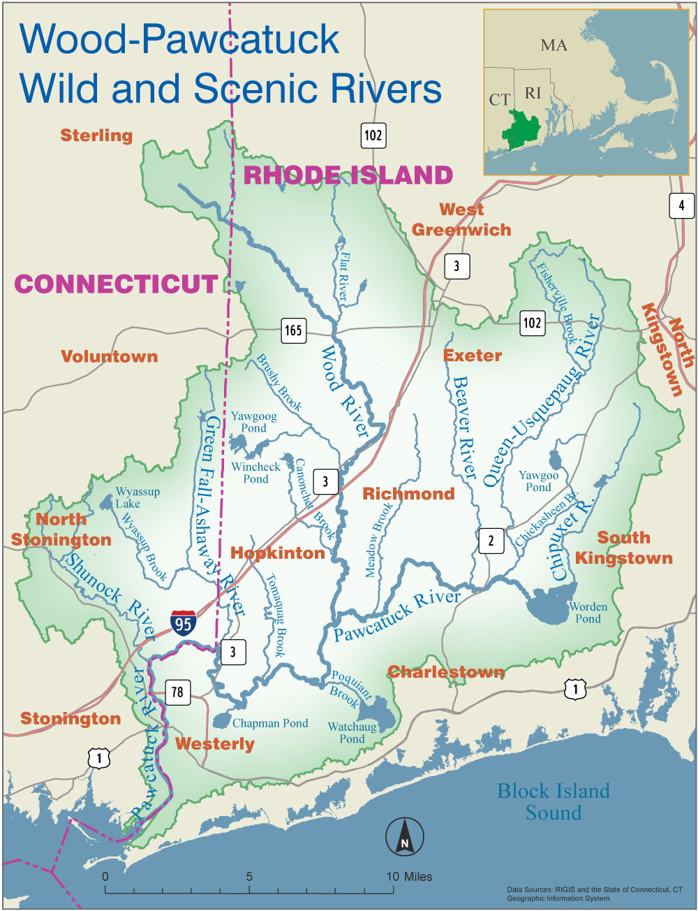
Tributaries:
Assekonk Brook, Breakheart Brook, Brushy Brook, Canonchet Brook, Chickasheen Brook, Cedar Swamp Brook, Fisherville Brook, Glade Brook, Glen Rock Brook, Kelley Brook, Locke Brook, Meadow Brook, Pendleton Hill Brook, Parris Brook, Passquisett Brook, Phillips Brook, Poquiant Brook, Queens Fort Brook, Roaring Brook, Sherman Brook, Taney Brook, Tomaquag Brook, White Brook, and Wyassup Brook.